Tuesday, 6 May 2014

Falmouth (Place) to Pentewan: March 2014

Falmouth to Pentewan
March 2014

This section on the picturesque Roseland Peninsula was covered while we were 'based' for the week at St Margaret's Park in Polgooth.  This is a lovely, secluded park of comfortable wooden chalets and is thoroughly to be recommended for self-catering accommodation.
 
St Margaret's Park

'Our' chalet
The hikes for the week were, once again, a variety of circular and linear walks, using a combination of car and bus to and from the beginning and ends of our daily expeditions.  Public transport in this area is very limited, so some careful planning is necessary.  In some places suitable bus services are non-existent: hence the need for circular walks!
 
We did not actually start at Falmouth.  The 'official route' uses two ferries: one from Falmouth to St Mawes and the second (seasonal) from St Mawes to Place.  Instead we picked up the Path at Place.  We hope that our failing to use the ferries will not be seen as our cheating our way along the Coast Path!  So far we had not used any of the ferries: either they were not operating when we might have used them, or it simply did not fit in with our itinerary.  We have no qualms about this: sometimes the lack of a ferry being available has meant our walking extra distances!
 
 
Falmouth to Portscatho
Sunday 16 March 2014

This was an easy circular walk, starting at the Porth Farm (National Trust) car park (there are also toilets here!).
 
Our chosen route was to continue down the lane to Bohortha before heading down to the creek below Place House.  A more scenic route might be to follow the footpath along the edge of Porth Creek which meets the public footpath at North Hill Point.
 
We had met a couple in the car park and we said where we were going.  They implied that we were not going the best way.  Nevertheless we set off - in our different directions - only to meet up again at the St Mawes ferry landing!  I think that they had chosen the better route!
 
At the lane to the church to the rear of Place House there was a notice advising that the coast path had been diverted following serious damage to the paths during the recent winter storms.  Upon closer examination, however, the closure was to be for a limited period only and by the time we were there it should be reopened.  Fortunately it was open!
 
Falmouth and St Mawes Castle from above Carricknath Point - on a rather grey day!
As we were making our way in an easterly direction towards Portscatho, we spotted some seals near to Island Rock near Killigerran Head: excitement indeed!
 
We enjoyed the peaceful, silent welcome of the United Church in Portscatho, helping ourselves, as invited, to an excellent cup of coffee from the machine that has been installed there.  The United Church is also to be found on the Small Pilgrim Places website.

Portscatho United Church

After a pause in the small chapel, we made our way back to Porth car park across the fields and the lane past Rosteague.

The South West Coast Path distance which we covered was 10.1km (6.25 miles) and 15.1km in total (9.5 miles).  The cumulative distance (from Minehead) was approximately 550km (341 miles).


Portscatho to Portloe
Monday 17 March 2014

This was a linear walk, firstly by driving to Veryan Bessybeneath for the Western Greyhound service 550 to Portscatho, parking in the small lay-by at the road junction.

On a rather grey day, setting out from Portscatho, the walk was easy to start with, becoming strenuous later.  We arrived at Portloe with plenty of time to catch the Western Greyhound service 551 back to Bessybeneath.

We considered stopping at The Lugger Hotel for an afternoon tea, but, in our hiking gear - and none-too-clean boots, we felt that we would be somewhat out of place in this rather stylish hotel and restaurant.  Instead, we ate our picnic lunch seated on the bench just a few yards from the main entrance of the hotel.

Portscatho from Porthcurnick Beach

Gull Rock


Portloe
The South West Coast Path distance which we covered in the day's walk was about 12.5km (7.75 miles), with a total distance of 13.2km (8 miles).  The cumulative distance (from Minehead) was approximately 561km (349 miles).


Portloe to Porthluney Cove (Caerhays)
Tuesday 18 March 2014


Although there is a bus service to Portloe, there are no suitable public transport links from Gorran Haven to Portloe.  We, therefore, covered the distance from Portloe to Gorran Haven in two sections. 

East Portholland

For the first part, we drove to Portloe and parked in the village car park and headed to Porthluney Cove with its backdrop of Caerhays Castle via West and East Portholland.

Primroses beside the Path
For our return to Portloe, we followed the lane up the hill and then for a further couple of hundred yards in the Caerhays Barton direction.  At the right-hand bend in the road (SW969413) passing through the gate and crossing the field to, once again picking up the Coast Path back down to East and West Portholland.  We followed the quiet country from West Portholland, lanes past Tregenna Wartha and Tregenna Farm, then taking the farm lane to Cruggan and field paths to the lane dropping down to Portloe.

The South West Coast Path distance which we covered on this day's walk only about 5.6km (a mere 3.5 miles), and the total distance covered was about 11.3km (7 miles). The cumulative distance (from Minehead) was approximately 567km (352 miles).


Porthluney Cove (Caerhays) to Gorran Haven
Wednesday 19 March 2014

This was another walk for which where there was no suitable public transport links so we did it as a circular walk from the National Trust car park at Penare Farm, about three-quarters of a mile from Dodman Point.

Dodman Point from Boswinger
From the car park, our route took us along the footpath which runs above and parallel to the lane which leads down to Hemmick Beach.  From Hemmick we crossed the field on the footpath to Boswinger (YHA Hostel, ideally placed for coastal walking), then followed the lanes to Tregavarras and the field path from there down to Porthluney Beach and Caerhays Castle.

Caerhays Castle
The Coast Path from Porthluney Cove leads around Dodman Point and above Vault Beach to Gorran Haven.  Our return route back to the car park was through Treveague Farm: its camping site quiet on this March day!

Gorran Haven

The South West Coast Path distance covered on this circular walk was about 8.4km (5.25 miles); the total distance was approximately 14km (8.75 miles). The cumulative distance (from Minehead) was approximately 575km (357 miles).
 
Gorran Haven to Mevagissey
Thursday 20 March 2014


We did this as a linear walk, initially driving to the Gorran Haven car park (£1.00 honesty box during the winter months; manned at other periods).  The walk took us through Gorran Haven village passing Great Perhaver Point, Turbot Point and Chapel Point, where we were very excited at spotted a seal!

Mevagissey on a grey day

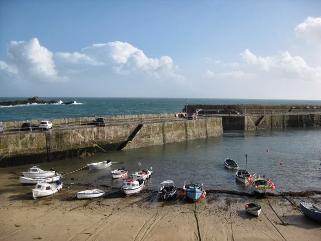
Mevagissey Inner Harbour at low tide

From Mevagissey towards Chapel Point
We reached Mevagissey at lunch time and enjoyed a meal at The Fountain Inn, after which we had a wander around the village - just as the rain started!

By the time Gorran and District Community Bus to Gorran Haven arrived at 15:35 we were very wet - and glad to be able to get out of the rain!

The bus service between Mevagissey and Gorran Haven is very limited, with different timings each day of the week. Careful planning may be necessary if one wishes to do this as a bus walk!

This was a short walk; the distance covered on the South West Coast Path was about 5.6km (3.5 miles) and the total distance covered was approximately 8km (5 miles). The cumulative distance (from Minehead) was approximately 581km (361 miles).

 
Mevagissey to Pentewan 
Friday 21 March 2014

This was a short, strenuous linear bus walk: the distance on the coast path a mere two miles!

We drove to Pentewan and parked the car in the free car park there before catching the bus to Mevagissey.  There is a good bus service to and from Mevagissey, with buses serving Fowey, St Austell and Pentewan.  Bus walks are easy to arrange.

As it was Friday morning, we called in to the coffee morning at St Andrew's United Church, where we received a warm welcome.  Afterwards we returned to the Fountain Inn for an excellent fish and chip lunch before setting out on our way to Pentewan.  It doesn't look very far on the map, but the route does have its fair shares of ascents and descents!

Pentewan from above Portgiskey
Arriving at Pentewan, with its superb stretch of sand and small harbour, we enjoyed the hospitality of the homely Pisky Cove Cafe, with a pot of tea for two and a toasted tea cake each.

As already mentioned, this was another short walk; the distance covered on the South West Coast Path was just 3.2km (2 miles); the total distance covered was approximately 5.3km (just over 3 miles). The cumulative distance (from Minehead) was approximately 584km (363 miles).

The total distance covered in the six walks of this session was approximately 51.8km (32 miles).


Monday, 14 April 2014

Coverack to Falmouth: March 2014

Coverack to Falmouth
March 2014

We covered this section with a total of four walks, staying for two nights at the excellent Lizard YHA and for a further two nights with a cousin of Elizabeth's near to Mawnan Smith.
 
Coverack (Car Park) to Pedn-myin
Sunday 09 March 2014
 
Our first walk was a very short 'out and back' along the Coast Path from the car park at the northern end of Coverack to Pedn-myin: a mere 1.35km (0.8 miles) each way.  This must have been the shortest day walk that we have completed on the coast path!

We had left home in the morning with the intention of walking a somewhat greater distance, but were delayed because of a road closure on the way to Coverack and we had arranged to meet with one of Elizabeth's cousins on the way to The Lizard.  We simply ran out of time!

We set out towards Lowland Point, but just past The Grove (above Pedn-myin), we met a couple who advised us that the way further on was very muddy and boggy.  With this warning in mind we retraced our steps; planning to incorporate the section round Lowland Point, if possible, as part of the walk the next day: Monday 10 March.

Pedn-myin to Gillan
Monday 10 March 2014

We walked this section in two parts: walking the northern section from Rosenithon to Gillen before the southern part from Pedn-myin to Rosenithon.  We did it 'out of order' so that we use the bus from Gillan to St Keverne:  just one bus a day!

St Keverne Square

We made an early start to drive to St Keverne, where we parked the car in The Square.  We did not want to miss 14:47 from Gillan Bus Shelter to St Keverne, or it would have been a three mile trudge across the fields - or a taxi!  I would have considered having to resort to a taxi a great failure!
 
We set off from The Square to join the Coast Path at the little hamlet of Rosenithon, then passing The Giant's Quoits on the inland route, avoiding the quarries, down to Porthoustock.  The route from Porthoustock to Porthallow once again follows an inland route, with the disused St Keverne Quarry and the MOD Radar station to the seaward side of the Path.  We knew that at Porthallow there was The Five Pilchards pub, which we had as an aim for a well deserved (so we thought, anyway) cup of coffee.
 
When we arrived there, the front door was open!  We were in luck!  When we peered inside, though, it was clear that they were not open: it was cleaning day!  They took pity on us, however, and offered us a coffee each.  A real Cornish welcome that was very much appreciated.
 

A Cornish Stile
After our coffees at the Five Pilchards we paused beside the nearby South West Coast Path half-way marker: 315 miles from Minehead; 315 miles to South Haven Point.  It had only taken us from September 2011 to get this far!  At this rate we should manage to reach Poole Harbour by September 2016!

Halfway there! At Porthallow

Another Path Diversion!
The Path on to Gillan led us around Nare Point with its observation point before taking us in a westerly direction towards Gillan. 
St Anthony Head & St Mawes


St Anthony in Meneage and Gillan Harbour
We made the short diversion to the ferry landing on the south bank of Gillan Creek and then retraced our steps to pick up inland route, through the daffodil fields to the lane at Gillywartha and the bus shelter at the top of the lane which leads down to Gillan.  We were there in good time for the bus, so we did not have to resort to the taxi!


When we do bus walks we always prefer to arrange things so that we can use the bus at the start of the walk. This means that we do not have to rush to catch a bus which may run only infrequently, or, as today: just one bus a day. 

On this occasion, if we were to do this as a bus walk the only practical solution was to walk early and then catch the bus back to St Keverne.  There was a bonus in this: we should then be able to complete the part of the walk from Pedn-myin to Rosenithon.

That is what we did!  After a short refreshment stop in the car at St Keverne, we once again set out from The Square on a 'panhandle' walk.  Our route took us past the village school and Trythance, then by the Dean Quarries to join the Coastal Path 200 yards or so from the quarry jetty.

We headed to the point above Pedn-myin (SW793193), where we had turned round the previous day.  The way past Lowland Point was not at all easy.  Although it was not hilly, it was very wet and boggy in places and the direction that we should follow was not all that clear.  Nevertheless we found our way; the relative discomfort being forgotten when we spotted a pod of dolphins and watched them elegantly leaping and diving off of Lowland Point.  One of the truly memorable moments of the Coast Path.

The route back to St Keverne took us around the desert-like landscape of the quarry workings to Rosenithon for the return to St Keverne.

The walk distances for the day (both walks): SWCP distance: 11.75km (7.25 miles); walk total: 18.5km (11.5 miles).
Cumulative distance from Minehead: approximately 521km (324 miles) (Over half way - see above!).

Gillan Creek to Helford
Tuesday 11 March 2014

A circular walk, parking the car at the car park above Helford.

We left the car park and followed the lane down to Helford, but instead of staying on the Coast Path to the ferry pier, we continued south and then south-east to Manaccan before dropping down to Gillan Creek to follow the Coast Path beside and (in places) along the road to St Anthony in Meneage, where we ate our picnic lunch, sitting on the conveniently placed seat outside the churchyard.

From St Anthony in Meneage we followed the Path, looping around St Dennis Head before heading in a westerly direction to Helford, where we continued down to the ferry pier (summer only ferry) before returning to the car for the drive to Mawnan Smith.

Walk distances: SWCP distance: 6.5km (4 miles); walk total: 9.5km (6 miles).
Cumulative distance from Minehead: approximately 527km (327 miles).

Helford Passage to Falmouth
Wednesday 12 March 2014

We started this linear walk by following the lane from the road junction at the entrance to Trebah Gardens (where there is a bus stop) down to Helford Passage before picking up the Coast Path towards Falmouth, passing Durgan on the way.


Durgan

Durgan
It was a grey, overcast day with only moderate visibility.  The mournful sound of the foghorn in the distance accompanied us for much of the way.  Nevertheless it did not rain and we enjoyed our day: picnicking at Rosemullion Head, where we caught sight of a seal, oystercatchers and cormorants, before continuing to Maenporth and Swan Pool; rounding Pendennis Point with its castle.  From the Point it was an easy walk past the docks and through the town to Princes Pier, where the ferry to St Mawes departs.


At the end of our walk we caught the bus from the main Falmouth bus terminus (The Moor) back to Helford Passage, Trebah Gardens.

Walk distances: SWCP distance: 16 km (10 miles); walk total: 17.5km (11 miles).
Cumulative distance from Minehead: approximately 539km (335 miles).


Saturday, 23 November 2013

Penzance to Coverack: November 2013

Penzance to Coverack
For this section of the Coast Path we were based in two YHA hostels.  We returned to the hostel at Penzance for a two night stay and then moved on to the excellent self-catering hostel at Lizard Point.
 
We made a last minute booking at Penzance so that we could take advantage of a reasonable weather forecast: starting this part of our walk on Saturday 09 November, driving down to Penzance in time to start our walk at about 1 pm.

Penzance (Alexandra Road) to Marazion
Saturday 09 November 2013

This was an easy more or less level walk, following the Esplanade from the seaward end of Alexandra Road.
 
The iconic St Michael's Mount just off of Marazion in Mounts Bay is always within sight on this section.


The day was dull - but, at least - to start with, anyway - it was dry.  We followed the path round to Marazion and when we reached there we discovered that the road in the centre of the village was closed.  We carried on, nevertheless, to the cemetery bus stop, where we had planned to catch the bus back to Penzance.
 

Near the bus stop, though, a 'local' suggested to us that the bus would not be going that way because of the road closure and that we should retrace our steps to the other (western) side of Marazion to catch the bus.  So, as it began spotting with rain,  we headed back through the village; the rain getting heavier all the while.  Not very pleasant!

When we finally reached the bus stop there was already a group of a dozen or so people overflowing from the small shelter - so we had to wait out in the cold and wet.  Not such a good start for our week's walk!
 
We had yet another wet walk - a very wet walk - from the bus station along the Esplanade and back to the car for the short drive to Penzance YHA, where - at last - we were able dry out.  We were very grateful that we were given a four bed room instead of the two bed room that we had booked.  Neither of us had to do that undignified climb onto the top bunk!
 
Penzance YHA
 
SWCP distance (to Marazion cemetery) approximately 5 miles with a total walked of about 7 miles.  Cumulative distance from Minehead: approximately 277 miles.
 

Marazion to Praa Sands
Sunday 10 November 2013

St Michael's Mount
Drove from Penzance Youth Hostel to Marazion to start the day's walk.  The weather in the morning gave us wonderful, clear views across Mounts Bay to St Michael's Mount.

Easy walking to begin with, becoming strenuous later.


Praa Sands

We caught the First service 2 bus from opposite the shop at Trewartha Road for the journey back from Praa Sands to Marazion.

The South West Coast Path distance for the day's walk was approximately 5 miles and a total walking distance of just under 7 miles.  The additional distance was because we wandered around Praa Sands somewhat aimlessly!  The cumulative distance on the Coast Path from Minehead to Praa Sands is about 282 miles.


Praa Sands to Porthleven
Monday 11 November 2013

 
'Move day' - from Penzance YHA to The Lizard YHA for the remainder of this section of the Coast Path.  Once again we made our own breakfast  before leaving the hostel at about 09:45, in time to stop at the Morrison's Supermarket for some basic supplies on the way to Porthleven.
 
Arrived in Porthleven with ample time to catch the bus from there to Praa Sands, so we spent a few minutes at The Brew House for an excellent coffee.  The First number 2 bus was on time and we left at 11:39, arriving at Praa to start waling about midday.
 
It was a grey and misty day with very little in the way of views to be seen.  Fortunately, though, the rain held off, so, at least, we kept dry.
 
The engine houses and mine workings near Rinsey loomed out of the mists like great giants.  The mist brought a unique atmosphere to this stretch, which, we felt sure, would have provided spectacular views, had the visibility been good.


On the way to Porthleven
Porthleven


Reaching Porthleven, with its harbour and cluster of houses and shops, we drove on to The Lizard YHA in the mist and as darkness fell. We enjoyed a warm welcome from the voluntary warden and made ourselves at home in our spacious room with a huge en-suite wet room. A perfect place to stay for our exploration of the Coast Path around The Lizard.

The South West Coast Path distance was approximately 4.5 miles and the total walk distance just under 6 miles. The cumulative distance from Minehead to Porthleven is 288 miles.

 
Porthleven to Mullion Cove
Tuesday 12 November 2013


It was a glorious, sunny, winter's day with high clouds and sunny spells: an enormous contrast to Monday's weather!

We left the hostel by car at about 08:40 and headed for Helston, where we parked in the free Lakeside car park on the Porthleven Road and caught the First service 2 bus to Porthleven for the beginning of the seven miles or so to Mullion Cove.

Porthleven
The route took us across Loe Bar with its single beach between The Loe and Carminowe Creek on the landward side and sea.

The Loe Bar
Along the way we also passed by Gunwalloe Fishing Cove,  Church Cove (the church was closed for repairs), Poldu Cove with its Marconi Museum and cliff-top monument.


Poldu
 
Poldu Cove
 
Marconi Monument: Poldu


Polurrian Cove, Mullion
A local man on his way to do some sea fishing said that he hoped to land a catch of sea bass.

We extended our walk to Mullion Cove before cutting inland to the Mullion Cricket Club to catch the First number 37 bus back to Helston.  This turned out to be the school bus which started from the school in Mullion.  Schoolchildren kindly gave up their seats for us as we boarded the bus.  One by one the children got off of the bus as it made its circuitous way to Helston: all the way down the lanes to Gunwalloe; returning the same way.

When we reached Helston we bought some basic provisions from a High Street store and from the Lidl supermarket before returning to The Lizard YHA.

Flora and Fauna spotted: Kestrels, cormorants and mushrooms of different types.

The South West Coast Path distance for the day's walk was approximately 7.5 miles and the total walk distance about 9 miles. The cumulative distance from Minehead to Mullion Cove is about 294 miles.


Mullion Cove  to Lizard Point
Wednesday 13 November 2013

Another good day: a few light clouds with bright sunny intervals.
 
Lizard YHA
 
We left the hostel early - in time to catch the 08:47 First service 37 bus to Mullion.  From the top deck of the bus we enjoyed watching the scenery pass by, at the same time having local points of interest drawn to our attention by a local gentleman.
 
Lizard Point from Kynance Cliff
 
 
Kynance Cliff
 
Arriving at Mullion Cricket Club, we alighted from the bus and retraced our steps to Mullion Cove and resumed our South West Coast Path walk from there, passing Mullion Head (National Trust), the delightful Kynance Cove; rounding Lizard Point before returning to Lizard YHA.  Along the way we found vast numbers of fungi!


The South West Coast Path distance for the day's walk was approximately 7.5 miles and the total walk distance about 9 miles. The cumulative distance from Minehead to The Lizard YHA is about 301 miles.


Lizard Point to Cadgwith and Thorny Cliff (Kuggar)
Thursday 14 November 2013


The path from Lizard YHA to Cadgwith is described as 'moderate, strenuous in places', promising a 'not very difficult' day's walk.  This was helped by generally good weather: somewhat windy and just a couple of fairly heavy showers.
 
The path took us past Housel Bay with its hotel looking out to sea, by Bass Point and Church Cove - and on to Cadgwith.  Shortly before reaching Cadgwith is the impressive collapsed cave called the Devil's Frying Pan.
 
The Devil's Frying Pan, Cadgwith
Being lunch time by the time we reached Cadgwith, we called at The Cadgwith Cove Inn for an excellent seafood chowder, before carrying on a short distance to eat our packed lunches overlooking the village.
 
The Cadgwith Cove
 

Cadgwith
After our lunch break we continued to Thorny Cliff, near Kuggar. then heading back to Ruan Minor to catch the bus to The Lizard.
 
Footbridge at Poltesco.
 

The South West Coast Path distance for the day's walk was approximately 5.3 miles and the total walk distance about 8 miles. The cumulative distance from Minehead to Thorny Cliff is about 306 miles.


Thorny Cliff (Kuggar) to Coverack
Friday 15 November 2013


A cloudy but dry day, but muddy underfoot in places.

The South West Coast Path Association handbook describes the distance between The Lizard and Coverack as 'moderate, strenuous in places'.  With that in mind, we set out by car from The Lizard YHA for the short drive to Kuggar.  The plan was to walk to Coverack and to catch the bus back to Kuggar.
 
We took the lane from Kuggar to the beach at Carn Kennack and then headed in an easterly direction towards Black Head, passing The Bees on the way.  At Black Head we found a little shelter from the strong wind beside the National Trust look-out before proceeding to Coverack via the inland diversion due to land slip at Chynhalls Cliff.  This took us, to our surprise, through a Sculpture Park before descending to the village of Coverack.
 
We had penty of time to walk around the village before catching the 16:15 bus to Kuggar that we had intended to catch, so we headed for the Fat Mackerel CafĂ©, where Elizabeth enjoyed a healthy and delicious fish stew and Vaughan an unhealthy and also delicious chocolate fudge cake.  All very good and thoroughly recommended.
 
On our way to the bus stop we met a couple who we had met the prevous day on the Coast Path.  They offered us a lift to Kuggar, which we gratefully accepted, as the lift saved us a good hour and a half on the bus.


The South West Coast Path distance from Thorny Cliff to Coverack car park was just short of 6 miles with a total walk of 7.3 miles.

During the seven days walking of the South West Coast Path we covered a distance of approximately 40 miles on the path, with the total distance walked being approximately 53 miles.

Friday, 22 November 2013

Morvah to Penzance: October 2013

Pendeen Watch Lighthouse
For the section of the Coast Path from Morvah to Penzance we were based at the Land's End (St Just) and Penzance YHA hostels and completed the 28 or so miles of the path in a week.  The total distance walked was just short of 40 miles.  This included additional distance getting to and from the Coast Path.  At the end of the week we reckoned that the cumulative distance from Minehead that we had walked was about 273 miles.

Morvah to Geevor Tin Mine

Monday 14 October 2013

We set out from home for Pendeen, Boscaswell Stores, where we parked the car in the free car park.  We then caught the Western Greyhound bus to Morvah, where we had prematurely finished walking in September.  The premature end to walking had been brought about by Vaughan painfully twisting his ankle, with rest 'prescribed' by the nurse at Bridport hospital.


At Morvah Church

Vaughan was not a little apprehensive about whether it was wise to be attempting to walk on a still rather tender ankle and whether it would hold up with the continued rigours of a 'severe' section of the path.  He embarked on the walk with caution: watching for any uneven surface that might present difficulty and put any extra strain on the ankle.  We had deliberately planned fairly short distances for the week.
 
So we set out, once again with spectacular coastal scenery every step of the way and with Pendeen Watch with its lighthouse as a goal.
 
Pendeen Watch is one of those significant headlands - along with Morte Point, Hartland Point and Trevose Head, and more - which had become aims along the way.  Once passed, they gave confirmation that progress had been made and with it a real sense of achievement.  There will be many more of these headlands and coastal landmarks before South Haven Point and Poole Harbour is reached!
 
With the change of direction at Pendeen Watch, we headed in a south-west, with hard rock mining in the region very much in evidence.  The Geevor Tin Mine finally ceased production as recently as 1992.  We returned to the car, passing by the now disused mine buildings, which are being revived as the tourist attraction of a museum and heritage centre, complete with restaurant.
 

Geevor Mine to Nanven and the Cot Valley

Tuesday 15 October 2013


Botallack Mine
For this linear walk we walked from Land's End YHA to the bus station in St Just to catch the bus to Geevor Mine.  St Just is described as 'the most westerly town in England'.  With a little imagination, it has just a touch of the 'wild west' about it!

Before catching the 10:37 First 10A bus, we paid a brief visit to the church and when we arrived at Geevor Tin Mine we headed straight to the Mine Cafe for an excellent carrot and lentil soup and a roll before setting out on the walk back to the hostel.

Evidence of mining is to be seen for much of the way, with mine workings and engine houses perched on the cliff tops.  These days it seems strange that this was an area of intense industrial activity.

Cape Cornwall
The Path heads south - and west - to Cape Cornwall: England's only Cape.  We did the circuit of the Cape, pausing to eat our picnic lunch at the foot of the 1864 chimney of the former Cape Cornwall Mine, which now commemorates the purchase of Cape Cornwall for the nation by the H J Heinz Company.  This is now National Trust property.

From Cape Cornwall, we followed the Path down to the Cot Valley, where we returned to Land's End YHA for a rest!

Land's End Youth Hostel
South West Coast Path distance: 4.6 miles; walk total approximately 6.75 miles.  Cumulative total from Minehead approximately 252 miles: to be celebrated with a Betty Stogs beer!
 

Land's End Youth Hostel to Sennen Cove

Wednesday 16 October 2013

The challenge was to get to Sennen Cove in time to catch the last direct bus back to St Just: the 14:20 Western Greyhound service 504*.  We left the hostel before nine for the four miles or so, passing more stunning scenery along the way; arriving at Sennen cove in plenty of time for the bus and with time to explore, eat our picnic and buy a coffee at the Little Bo Cafe.
 
The going of this section is described as 'moderate'.  It was, however, not without its challenge in places - at least with a sore ankle!  There was some negotiating of rocky and uneven paths and some scrambling over rocks.
 
At Aire Rock we came across some workmen carrying out some improvements by building some steps over a rocky obstacle.
 
Whitesand Bay from Sennen Cove
On this walk on this warm and sunny day we found some field mushrooms, kestrel, gannets diving for fish in Whitesand Bay and cormorants at Sennen Cove.
 
Distance walked on the South West Coast Path was about 4 miles with total walk of just over 6 miles.  The cumulative distance from Minehead: approximately 255 miles.

*Note: Western Greyhound service 504 ceased operating 02 November 2013.


Sennen Cove to Minack Theatre, Porthcurno

Thursday 17 October 2013

An early start (9am) from Land's End YHA to the Minack Theatre car park (honesty box) in time to catch the 09:59 Western Greyhound service 504* bus to Sennen Cove.

Land's End and Longships Lighthouse in the haze
Before setting out on the Path, we paused for a coffee at the Little Bo Cafe and then headed out, with the first goal of our day's walk being Land's End, where we took an early lunch break and bought delicious, hot, fresh, Cornish Pasties from Warren's kiosk.

At Land's End
After the obligatory photographs - close by the famous signpost, we headed on, leaving the crowds behind with the Minack Theatre as our goal.  Once again, the scenery was absolutely stunning.

Rock Arch and Longships Lighthouse

Hard Rock Cliffs

Evening Light
Flora and fauna spotted along the way included buzzards, kestrel, heron, seals as well as caterpillars and butterflies; sea thrift and blackberries.

South West Coast Path distance: just over 6 miles, with a cumulative distance from Minehead of 262 miles.


*Note: Western Greyhound service 504 ceased operating 02 November 2013.

Minack Theatre, Porthcurno to Lamorna Cove

Saturday 19 October 2013

We had a 'rest' day on Friday.  The weather was promising to be horrible all day, so decided that, instead of walking in the rain, which we thought would not be much fun, we would visit the Geevor Tin Mine.  An excellent choice of a wet-weather activity, which, together with the above- and underground tour took us all day.
 
We resumed our Coast Path walking the next day, at first by driving to the small layby near to the Merry Maidens stone circle.  We had arrived in time to catch the 09:41 Western Greyhound service 504 (this service ceased to operate in November 2013). 
 
When we arrived there it was raining and from inside our car we watched a steady downpour.  Was it a stupid thing to try to walk a tough stretch of coast path on such a day?  We had almost given up on the idea, when - less than ten minutes before the bus was due, the rain stopped: the comedy hit single by Allan Sherman 'Hello Muddah, Hello Fadduh', comes to mind!
 
Hurridly we 'booted-up' and got ourselves ready, just in time to catch the bus, which was absolutely on time, to the Minack Theatre car park.

Logan Rock, Porthcurno


At Porthcurno

 
The South West Coast Path Association's handbook describes this section as 'moderate', but Vaughan, at lease, found the going somewhat difficult: his 'crocked' ankle was not helping!  Underfoot it was rocky and muddy.


Penberth Cove

Lunchtime at Penberth Cove

Coral Fungus
It had been our intention to walk as far as Boscawen Point and Zawn Gamper and then turn inland, taking the lane past Tregiffian Farm to the layby near the Merry Maidens.  The map suggested that this might be possible, but the gate to the farm lane had a very clear 'Private - No Footpath' notice on it, so we continued the extra mile or so to Lamorna Cove, enjoying, so we convinced ourselves, a pot of tea and a delicious 'sticky ginger' cake.
 
Tater-du Lighthouse

Our return to the car was up the delightful valley to the Cove and then up the lane to New Town and crossing the fields, passing through the centre of the Merry Maidens stone circle.  After a wet start to the day, the weather improved as
 
The distance covered on the South West Coast Path was approximately five and a half miles, with a walk total of about 7 miles.  Total distance (from Minehead): about 268 miles.


Lamorna Cove to Penzance (Alexandra Road)

Sunday 20 October 2013

A wet morning!  Instead of an early start we had a leisurely start to the day and walked from Penzance YHA to catch the 11:28 bus to Lamorna Turn for the walk down the lane to the Cove to begin on the Coast Path. 

Once again, before beginning our Coast Path walk, we stopped at the cafe, this time for a light lunch of delicious crab, fish and vegetable soup.


Lamorna Cove

Setting out from Lamorna Cove
To start with the way was strenuous; Vaughan continued to find the downhill and rocky stretches quite difficult.  After Mousehole, where we stopped for our picnic lunch overlooking the harbour, the way underfoot was easy, mostly hard-surfaced.

Mousehole Harbour

Newlyn

On the way to Penzance

Penzance YHA
The day's walk total was approximately 8 miles; 5 miles was on the South West Coast Path.
During the week we covered approximately 28.5 miles of the South West Coast Path and the total distance walked was approximately 39 miles.  The cumulative total (from Minehead) is about 273 miles.