
June 2013
A week's walking from Tintagel to Harlyn Bay with a mixture of circular and linear walks. We used a combination of bus and/or car to get to the beginning and end of the walks.
Accommodation for the week was at Delamere Holiday Bungalows, Delabole. The bungalow provided good value, simple accommodation, ideal for our purposes with the bonus of wide open inland views.
Accommodation for the week was at Delamere Holiday Bungalows, Delabole. The bungalow provided good value, simple accommodation, ideal for our purposes with the bonus of wide open inland views.
 |
| Delamere Holiday Bungalows, Delabole |
Tintagel Church to Trebarwith Strand
(3km/2 miles)
Saturday 08 June 2013
Arriving at Tintagel we enjoyed a picnic lunch at the National Trust car park at Tintagel Church, with views out to sea. We had originally planned to visit the castle, but decided to take advantage of the beautiful, hot, sunny day, and do a circular walk on the stretch to Trebarwith Strand, instead. This is a section with spectacular coastal views and interesting abandoned quarries, some with fantastic rock-hewn formations.
 |
| Trebarwith Strand |
Trebarwith Strand, with Gull Rock about half a mile offshore, has a cafe and pub. We enjoyed an excellent pot of Assam 'tea for two' (£2.00) at The Strand Cafe before returning to the car along 'inland' paths and tracks through the village of Treknow and the tiny settlement of Tregatta.
Walk total approximately 5.9 km/3.5 miles; South West Coast Path cumulative total: 238 km/148 miles.
Trebarwith Strand to Crookmoyle Point (Approximately 5.9 km/3.5 miles)
Sunday 09 June 2013
Another glorious, hot sunny day!
A circular walk, parking the car at Trebarwith before crossing the fields to Trebarwith Strand. Once again we enjoyed the hospitality of The Strand Cafe for a coffee before embarking on the walk 'proper'.
 |
| The Strand Cafe, Trebarwith Strand |
This is a strenuous - even severe - section with high cliffs cut by a series of valleys: some of them precipitously steep-sided. From Trebarwith Strand the Path climbs steeply up above Dennis Point and then, almost immediately down to Backways Cove and then up, again, to Treligga Cliff. The Path continues towards Tregardock Beach, a delightful, isolated beach with a glorious expanse of golden sands and then on to Jacket's Point with its steep-sided valley.
Our route left the South West Coast Path at the footpath that leads to the ruins of Dannonchapel (NT). According to Wikipedia, Dannonchapel was mentioned in the Domesday Book (1086) and was occupied by one villein and four serfs.
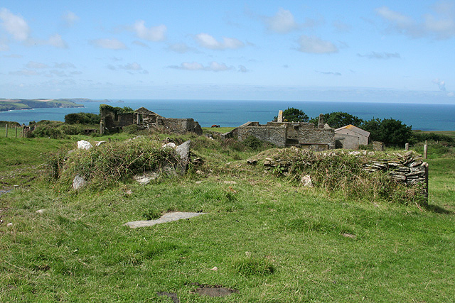 |
| Dannonchapel (Courtesy: Wikipedia) |
Our route back to Trebarwith took us past the modern Tregragon Farm and the lane to Treligga. We were expecting a quiet country lane, but, instead there was a constant flow of traffic in both directions. At Treligga we discovered the reason for this: one of the gardens was open as part of the National Gardens Scheme (see the Cornish Guardian article).
The footpath had been re-routed to avoid going through the Trecarne farmyard and we missed the way, trying to follow the old signs, which were still in place. All rather confusing! The young farmer's wife, however, pleasantly set us on the right path - across a field with a huge bull in it with his many wives. We were assured that he was just a big 'softy' and really quite harmless. Nevertheless, we did not dawdle across the field!
Walk total approximately 13.6km/8.5 miles; South West Coast Path cumulative total: 244km/151 miles.
Crookmoyle Point to Port Isaac Harbour
(Approximately 5.5km/3.5 miles)
Monday 10 June 2013
We returned to the Coast Path near Crookmoyle Point, passing once again the ruins of Dannonchapel. The route, again, is a wonderful, craggy section with a good number of steep-sided valleys and inlets.
After the quiet and relative loneliness of the cliff-top path away from habitation, Port Isaac seemed to us to be a very busy honey-pot of a place! To add to the excitement, filming of the television series 'Doc Martin' was taking place while we were there.
 |
| Port Isaac |
After a picnic lunch sitting on a harbour wall, we caught the bus from the Pea Pod bus stop back to Delabole. The driver kindly dropped us off at the lane to Delamere Holiday Bungalows.
Walk total approximately 11 km/7 miles; South West Coast Path cumulative total: 250 km/155 miles.
Port Isaac Harbour to Lundy Hole
(Approximately 6.5 km/4 miles)
Tuesday 11 June 2013
Drove to a small pull-in near to the Bee Centre and then caught the little green Western Greyhound bus from Porteath, Port Quin Cross to Port Isaac for the beginning of the walk. Before doing so, though, we stopped for a coffee at the Old School Hotel and Restaurant.
This is described as 'a rollercoaster of a path, closely following the ups and downs and ins and outs of the quiet, scenic but energy-sapping coast' (South West Coast Path Association). That was our experience!
A high-point was seal-watching at Downgate Cove. Along the trail were wild flowers in abundance: bladder campion, red campion, valerian in pink, white and red, kidney vetch, wild roses, fox gloves, oxe-eye daisies, bittersweet and thrift, to mention just a few.

Our route from the little bay below Lundy Hole was across the fields to the farm at Porteath and the lane past the Bee Centre and back to the car.
Walk total approximately 9.6 km/6 miles; South West Coast Path cumulative total: 256 km/159 miles.
Lundy Hole to Polzeath Beach
(Approximately 7.5 km/4.5 miles)
Wednesday 12 June 2013
One of those wet days that you don't want when you plan a walk! For this reason we started our day's walk rather late, having spent the morning in the bungalow watching the clouds and the rain.
We drove to the Lundy Hole National Trust car park and started our walk at about 4pm - for an early evening circular walk to Polzeath. At first we followed the footpath from opposite the car park and headed down to the little bay just below Lundy Hole before following the Coast Path proper up to the Hole: a collapsed sea cave.
 |
| Lundy Hole |
The Path took us past The Rumps and on to turn the corner at Pentire Point, heading then in a south-easterly direction along the Camel estuary towards Polzeath Beach with its surfers. We paused for a picnic tea at Pentireglaze, having got rather wet wading through the long wet grass combined with the rain showers. In addition to that, the very strong wind was a constant challenge, nearly blowing me off my feet at Pentire Point!
Walk total approximately 11 km/7 miles; South West Coast Path cumulative total: 263 km/163 miles.
Polzeath Beach to Rock (Ferry)
(Approximately 4 km/2.5 miles)
Thursday 13 June 2013
Another late(ish) start to catch the Western Greyhound bus, 12:17 from the Clock Garage in Rock to Polzeath Beach (£2.20). We had parked the car in the layby in the lane opposite the Spar stores.
Arriving at Polzeath it was time for coffee so we stopped at The Galleon Beach Cafe (check it out on Tripadvisor..... we didn't!). Coffee was OK: an Americano and Café Latte at £4.88 was plenty, though.
From Polzeath the Path heads in a southerly direction to Trebetherick Point, with Daymer Bay and Brae Hill coming into view.
We intended to head straight for St Enodoc Church, but my navigation skills let me down and we missed the direct footpath from Daymer Bay across the golf links to the church. Instead we followed the path that skirts the eastern side of the hill and approached the church from the south.
 |
| St Enodoc Church from Brae Hill |
After sitting on a seat in the churchyard for a picnic and visiting the church we returned to Daymer Bay and continued to Rock on the Coast Path - this side on the seaward side of Brae Hill.
 |
| The Rock to Padstow Ferry |
From the ferry we returned up the road to Rock, stocking up with provisions at the Spar store on the way.
The afternoon was bright and sunny with a fair fresh breeze: very good for walking.
After returning to the bungalow, we decided that a meal out would be a good idea and had a steak dinner at The Mill House, Trebarwith. The two steaks with all the trimmings at £20.00, we thought represented good value. We thought the complimentary soda bread rolls tasted a bit odd, though. We would have preferred ordinary bread or rolls!
Walk total approximately 9.6 km/6 miles; South West Coast Path cumulative total: 268 km/166 miles.
Padstow to Harlyn Bay
(Approximately 11 km/7 miles)
Friday 14 June 2013
 |
| Padstow Harbour |
Another bad weather forecast for today! We decided to 'go for it', however, and were rewarded by having a good walk - with, in the event, very little rain. At one point, though, when we were near to Stepper Point, it did start to rain - and was threatening heavy rain, so we donned our watherproofs. Almost immediately, though, the rain stopped!
 |
| The Camel Estuary from north of Padstow |
We drove to the Harlyn Bay car park (£4.00 for the day) and then caught the 11:13 Western Greyhound 556 bus to Padstow. We set out from Padsow on this easy, gentle section, arriving at Hawker's Cove at about 1pm - just in time for a bowl of very good home made leek and potato soup and a pot of tea (£10.20) at the unique Rest a While Tea Garden. Things were getting busy in the tiny back garden of the terraced house and we shared the picnic table with a couple from St Helens and two women - also from Merseyside - exchanging stories of our travel experiences. Food and drinks are all served from the back kitchen through the window - and there is no inside seating.
After spending a leisurely hour at Rest a While we set out again, stopping for a little more lunch at Trevone Bay. We reached Harlyn Bay just as it started to rain and were glad to have a flask of tea in the car, watching the rain.
Walk total approximately 12.3 km/7.5 miles; South West Coast Path cumulative total: 279 km/173 miles.
Details of the South West Coast Path may be obtained from The South West Coast Path Association. The Association annually publishes a comprehensive guide, which is free for members.
For maps I like to use the Ordnance Survey 1:25,000 Explorer series and I find it very handy to print off relevant sections on A4 sheets. This saves having to carry large maps, which have to be unfolded and re-folded repeatedly! OS offer a good value subscription to GetaMap which enables one to do this - and much more.
For some sections of the Path we are 'back-packing', used a combination of bed and breakfast accommodation and Youth Hostels. For other sections we often use a combination of the car and buses to get to the beginning and from the end of the day's walk. Sometimes, where the bus services are very limited, careful planning is needed! The Traveline website is a valuable tool for this, with maps of bus routes, the location of bus stops and timetables.
No comments:
Post a Comment