Wednesday, 27 August 2014

Hope Cove to Dartmouth: July 2014

Hope Cove to Dartmouth:
July 2014

A series of six circular and linear bus walks to cover the delightful stretch between Hope Cove and Dartmouth.  We stayed in Meadow Barn Cottage, East Prawle, self-catering accommodation, booked through Toad Hall Cottages in Devon.

Hope Cove to Salcombe
 
The first day's walk was a linear bus walk from Hope Cove to Salcombe, catching the Tally Ho! 162 bus from Malborough to Hope Cove for the start of the walk and the Tally Ho! 606 bus from Salcombe back to Malborough at the end.

A splendid warm and sunny day for the first walk of the week!

Firstly driving to Malborough (free car park at the village hall) to catch the bus (Tally Ho! 606) to Hope Cove for the walk to Salcombe.

This section is described as 'strenuous' in the South West Coast Path Association Handbook.  A fair description, we thought!  Some of the rocky outcrops reminded us of the Valley of the Rocks near Lynton, North Devon.

We somehow managed to miss the way near to Bolt Head: maybe I wasn't paying proper attention to the signs or the map?  Instead of following the Coast Path proper, we found ourselves clambering down the steep, rough path at Starehole Bottom - about 500 metres up the valley from Starehole Cove, near to the footbridge on the direct path to Salcombe.  We headed down the valley to the Cove to pick up the correct path and headed to Salcombe to catch the bus back to Malborough.

Birds spotted: skylarks and stonechats.
 
Salcombe Ferry - at Salcombe


SWCP from Hope Cove to Salcombe: 13.1km (8.1 miles);
Walk total: 14.5km (9 miles).

Cumulative distance from Minehead: 730km (454 miles);
Distance to South Haven Point: 284km (176 miles)
(Saturday 05 July 2014)


East Portlemouth to Prawle Point
 
Day two: a circular walk from Meadow Barn Cottage.

There are no suitable public transport links between East Portlemouth and Torcross so we did the East Portlemouth to Prawle Point and Prawle Point to Start Point sections as circular walks with inland return routes.


Kingsbridge Estuary from East Portlemouth

Salcombe from East Portlemouth
For this day's walk we set out from Meadow Barn Cottage, down the lanes to East Portlemouth, with just the final 500 metres or so down to the Salcombe ferry and the South West Coast Path via the public bridleway.

Salcombe Ferry - at East Portlemouth 
This is a lovely stretch of Coast Path - on quite a busy Summer Sunday, with many people walking the popular circuit from Mill Bay to Rickham Common, Portlemouth Down and Gara Rock.

Salcombe from Mill Bay
After Gara Rock, passing Pig's Nose and on to Prawle Point with its Coastwatch lookout station, we seemed to leave the crowds behind and the path was relatively quiet.


Elender Cove and Gammon Rock
 
Rounding Prawle Point, we left the Coast Path above Western Cove and headed to the village of East Prawle via the lane, returning to Meadow Barn Cottage across the fields and along the lanes.

Flowers and butterflies in abundance; also grasshoppers and small bright yellow 'miner' bees (we think!).  Sea peas, yarrow, common toadflax and birdsfoot trefoil - to mention but a few!

SWCP from East Portlemouth to Prawle Point: 8.0km (5 miles);
Walk total: 14.9km (9.25 miles).

Cumulative distance from Minehead: 738km (458 miles);
Distance to South Haven Point: 276km (171 miles)
(Sunday 06 July 2014)

Prawle Point to Start Point
 
Day three: a circular - or more like a 'banana-shaped' - walk from East Prawle to Start Point with an inland return.

Prawle Point from Western Cove
 
Driving, firstly, to East Prawle (parking available by village green) before retracing our steps along the lanes to join the Coast Path above Western Cove.  Another spectacular stretch of path around Lannacombe Bay - with some uneven and rocky parts where some scrambling was needed.

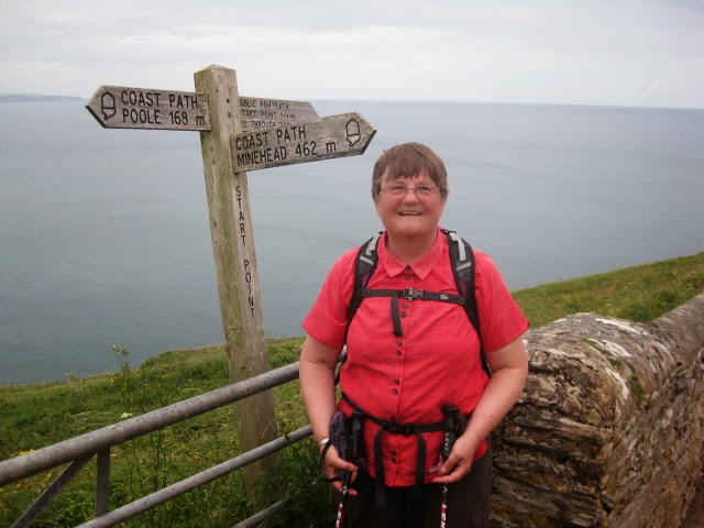
At Start Point: only 168 miles to go!
 
Our return from Start Point (car park) to East Prawle  was along the lane, passing the communication masts, then along the lane to Lannacombe Green before following the bridleway to the village.  At Lannacombe Green we followed what appeared to us to be the more obvious route - the track-way running in a southerly direction with the stream to the left.  We realised that we had missed our way when the track was blocked by a fallen tree and we studied the map!  The correct bridleway headed steeply up hill from the road (SX801383) in a south-westerly direction: passing Higher Borough and Woodcombe.

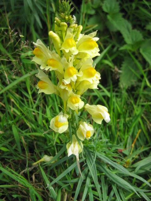
Toadflax
A naturalist carrying out a butterfly count helped us to identify some of the butterflies that we had seen: gatekeepers (a new one for us), peacocks and the small tortoishell.  In addition, among plants and flowers that we found were sea pea, black pea, everlasting pea, wild carrot, yarrow, ribbed melilot, speedwell toadflax and valerian.  We also spotted the rare cirl bunting, a species which, with conservation measures which are being taken, is doing well in the area.

SWCP from Prawle Point to Start Point: 8.0km (5 miles);
Walk total: 15.8km (9.75 miles).

Cumulative distance from Minehead: 746km (463 miles);
Distance to South Haven Point: 268km (166 miles)
(Monday 07 July 2014)


Start Point to Beesands
 
Day four: a return linear walk from Start Point (car parking in the free car park at Beesands).  This was a short walk when compared to the three previous days!

Start Point

We set out from Beesands at about 10:00am after a leisurely start to the day, and headed south to Start Point: the 'wrong' 'clock-wise' direction on the path.  At about 11:00am, having reached Hallsands, we paused for a welcome cup of coffee from our flask, seated on the conveniently-placed bench just above Greenstraight.
 
Hallsands
Arriving at the Start Point car park, we enjoyed an Asian Style Pork Slider and tea, which we bought from the Surf and Turf refreshment van (£5.50).  An excellent snack: we had the last one!
 
Surf and Turf refreshment van at Start Point
Returning to Beesands after our refreshment stop, we followed the short detour to the Hallsands viewing platform with its panels explaining how - and why - the coastal erosion had taken place to cause the loss to the sea of the buildings.
 
 
We arrived back at the car at Beesands just as the heavens opened with a torrential downpour - just in time to avoid a drenching!

SWCP from Start Point to Beesands: 3.6km (2.25 miles);
Walk total: 7.3km (4.5 miles).
Cumulative distance from Minehead: 750km (466 miles);
Distance to South Haven Point: 264km (164 miles)
(Tuesday 08 July 2014)

Beesands to Stoke Fleming
 
Beesands and Widdicombe Ley


Day five: a linear walk from Beesands (car parking in the free car park at Beesands) to Stoke Fleming with a mile return section between Beesands and Torcross.
 
We set out from Beesands on this mostly easy-going walk at about 8:45am, firstly along the level path along the shingle bank between Widdicombe Ley and Bee Sands and then behind Beesands Quarry down to Torcross Point.
 
Sherman Tank War Operation Tiger memorial at Torcross

Blackpool Sands
 
The Path continues from Torcross parallel to the main road across Slapton Sands as far as Strete Gate, then on to Strete, Blackpool Sands and Stoke Fleming.  Return to Beesands, firstly by bus from Stoke Fleming to Torcross and then walk back to Beesands.
 
Letterbox House, Stoke Fleming
Butterflies spotted: comma, red admiral, peacock and large white; flowers and plants: tansy, viper's bugloss and foxglove.

SWCP from Beesands to Stoke Fleming: 10.7km (6.5 miles);
Walk total: 13.6km (8.5 miles).
Cumulative distance from Minehead: 761km (472 miles);
Distance to South Haven Point: 253km (157 miles)
(Wednesday 09 July 2014)

Stoke Fleming to Dartmouth

This was another linear walk - from Stoke Fleming (free car park near to the church, in School Road) to Dartmouth - with the bus return from the Pontoon bus stop in Dartmouth to Stoke Fleming.

After parking the car in Stoke Fleming we repeated the short stretch of the official Coast Path along Rectory Lane and Ravensbourne Lane - alongside the recreation ground - to the lane to Redlap.

Above Compass Cove we made good use of a conveniently placed bench for our picnic lunch stop before continuing on our way to Dartmouth, passing Blackstone Point, Dartmouth Castle and Warfleet on the way with the Dart Estuary busy with boats.

Dartmouth and (right) Kingswear Castle

We finished out picnic lunches on a bench among the Dartmouth crowds looking across the River Dart to Kingswear.

Kingswear from Dartmouth

Our journey by bus back to Stoke Fleming was uneventful.  It was, however, after leaving Stoke Fleming that events started to happen!  On the way back to Meadow Barn Cottage we decided to stop at the Slapton Sands car park and were tempted to hot dogs and tea from the refreshment van there.  We also visited the granite monument commemorating the ill-fated WWII 'Operation Tiger' in which 749 United States servicemen lost their lives in a disastrous rehearsal for the D-day landings.

Unbeknown to us, Vaughan dropped the key to the cottage in the car park; it was only when we reached Meadow Barn that we realised that the key was missing and at the same time Vaughan's eye began to haemorrhage once again.

There was nothing for it, but to return to the Slapton Sands car park in the hope that we would find the key: fortunately we did!  After a meal, we quickly packed up and left the cottage a day early to head for the Dorchester County Hospital Accident and Emergency Department.

This time we lost just one day - and we had achieved what we had set out to do: namely walk the stretch of the South West Coast Path from Hope Cove to Dartmouth.

SWCP from Stoke Fleming to Dartmouth: 6.8km (4.25 miles);
Walk total: 8.25km (5 miles).

Cumulative distance from Minehead: 767km (477 miles);
Distance to South Haven Point: 246km (153 miles)
(Thursday 10 July 2014)


Monday, 11 August 2014

River Yealm (Noss Mayo) to Bigbury-on-Sea & Hope Cove: June 2014

River Yealm (Noss Mayo) to Bigbury-on-Sea & Hope Cove
Monday 09 to Monday 16 June 2014

A few personal notes of our South West Coast Path expedition - a sort of scrap-book.  You are welcome to view and make comments if you wish! 
 
You will see that we are taking our time to complete the Path - we started out from Minehead in September 2011.


A series of bus walks using the very limited bus services in this part of Devon to reach our walks.  Careful planning was ncessary and we did the walks slightly out of sequence so that we could use the Friday-only service from Challaborough to Kingston for the walk from the Erme Estuary to Challaborough.
 
We stayed in a mobile home at the Parkdean Challaborough Bay Holiday Park, close to Bigbury-on-Sea for the week.  The Coast Path passes right by the entrance to the Park.
 
River Yealm (Noss Mayo) to Beacon Hill
Our first walk of the week (Tuesday 10 June) was from opposite Warren Point on the Yealm estuary to Beacon Hill.  There were two options for this walk: one was to catch the one bus per day (Tally Ho! 94) at about 9:36am from the Membland, Leaning Chimney stop or to do a circular walk. 
 
The bus-walk option worked!  We had identified where we might park the car - in the small lay-by in the narrow lane at the road junction (SX577472) and just a couple of hundred yards from the bus stop.  We alighted from the bus at Noss Mayo Church and walked the mile or so the the Coast Path at the Warren Point ferry landing.  We had hoped that we might be able to buy a coffee somewhere in Noss Mayo, but the pub was closed!
 
We continued on the Coast Path as far as Beacon Hill and returned to the car.  For much of the way the Coast Path follows the old carriage road with easy, level walking.
 
Weather was much better than we had expected: just a couple of very short showers; otherwise good with sunny spells.
 
Flora and fauna spotted on this section included foxgloves, elderflower, hogweed, red campion and valerian: white, pink and red.  Skylarks, yellowhammer, an unidentified warbler and butterflies and bees.
 
SWCP distance from Warren Point to Beacon Hill: approximately 9.1km (5.6 miles). 
Total walked: 11.1km (7 miles).
Cumulative distance (from Minehead): 695km (432 miles);
Distance to South Haven Point: 320km (199 miles)

10 June 2014

Beacon Hill River Erme Crossing

The next day (Wednesday 11 June) we continued on from Beacon Hill.  This time parking the car at the side of the road in the hamlet of Battisborough Cross and catching, once again, the Tally Ho! 94 bus: this time to Membland, the Leaning Chimney.

Erme Mouth
This is a delightful stretch of the Coast Path to the Erme Estuary.  There is no ferry here and the estuary can be crossed safely only about an hour either side of low tide.  We had long previously decided that we did not want to get our feet wet and had decided, instead to continue on the other side of the estuary on another day!  You can tell from this that we are not 'purists' so far as this expedition is concerned!

Vaughan had left his sun hat in the car, so Elizabeth generously let him have hers for the walk; she wore her warm 'winter' hat instead - on a day when temperatures were heading into the low 20's!

At a stile just below St Anchorite's Rock was a herd of cattle  blocking the way.  As we were deciding how best to deal with the situation (cattle can be a bit frisky at times), we were rescued by a friendly farm worker, who saw us safely past the cows and on our way.

Looking across the Erme Estuary from the slipway
From the slipway, near to the Old Coastguard Cottages, where we enjoyed our picnic lunch sitting on the rocks, we headed back to the car at Battisborough Cross up the lane.  There we took advantage of the bench at the cross roads for a (flask of) tea stop.  What we had not realised, was that the seat had recently been painted and Vaughan got some paint on his trousers.

Flora and fauna spotted on the way included: sheepspit scabious, scarlet pimpernel, mushrooms on ash tree root; kestral, stonechat and goldfinches.

SWCP distance from Beacon Hill to the Erme Crossing: approximately 5.3km (3.25 miles).
Total walked: 9.0km (5.5 miles).
Cumulative distance (from Minehead): 700km (435 miles);
Distance to South Haven Point: 315km (196 miles)

11 June 2014

Erme Crossing to Challaborough Bay

There is just one bus a week from the Challaborough Slipway Cottage bus stop - and that is the Tally Ho! (service 875) to Plymouth.  This bus goes via Kingston: just a mile or so across the fields from Erme Mouth, enabling us to do this section as a bus walk.  This is the reason why we did this section 'out of sequence' - on Friday 13 June 2014.

There were about half a dozen or so of us waiting for the bus: quite a few were going all the way to Plymouth.  It was a very hot morning and the bus was about half an hour late.  Eventually it arrived and by the time we had all got one I don't think that there was a spare seat.

The Dolphin, Kingston
With two other walkers we alighted at Kingston and headed across the fields and through Wrinkle Woods to the Coast Path at Erme Mouth, a popular unspoilt spot for holiday-makers and local families alike.

Erme Mouth
After first heading south to The Beacon, just inland from Beacon Point, the path takes an easterly direction with Burgh Island coming into view in the distance.


Burgh Island (in the middle distance)
 

Approaching Burgh Island
This stretch is described in the South West Coast Path Association's handbook as 'strenuous'.  Our experience bore this out with significant ascents in places!

Flora and fauna seen on this section included scarlet pimpernel, poppies, sea spurrey, thistles and speedwell; black-backed gull, jackdaws and (we think) whitethroats ... and lots of butterfies.

South West Coast Path distance for the day's walk was approximately 6.7km (4 miles). Total walked: 10.3km (6.4 miles).

Cumulative distance (from Minehead): 710km (441 miles) and distance to South Haven Point: 320km (192 miles).

Challaborough Bay to Cockleridge Point

We walked the short section between Challaborough Bay to Cockleridge Point and the Avon Estuary ferry crossing on Sunday 15 June.

Setting out from Challaborough Bay Holiday Park, we headed around Bigbury-on-Sea, passing Burgh Island.  We found that the way-marking near to Sharpland Point was not very clear, and we missed our way and headed out to Sharpland Point and missed the permissive path (the 'official' route) on the northern side of Folly Hill, following the lane, instead before descending down to Cockleridge Point and the ferry to Bantham.

Avon Estuary with Bantham on the far side
From the ferry landing, we returned to Bigbury-on-Sea across the fields and golf course before crossing the sand spit to Burgh Island, where we completed a circuit of the island before returning to the mainland for a picnic lunch on the beach.
Challaborough Bay from Burgh Island
South West Coast Path distance for the day's walk was approximately 3.2km (2 miles). Total walked: 11.3km (7 miles).

Cumulative distance (from Minehead): 713km (443 miles) and distance to South Haven Point: 317km (190 miles).

Avon Estuary to Hope Cove

As mentioned earlier, the section from the Avon Estuary to Hope Cove was completed out of order - on Thursday 12 June: a beautiful hot and sunny day with fluffy white clouds.  On this occasion Vaughan remembered his sun hat!

This was a linear bus walk, taking the Tally Ho! 162 bus from Outer Hope to Thurlestone Church for the half mile walk down to Bantham, where we rejoined the Coast Path.
 
Avon Estuary at the ferry crossing
This is a moderate section.  At the time that we did it, we followed the sign-posted diversion from above Thurlstone Sands inland up the lane to Pitchingstone Cross and joining the 'official' path at Woolman Point before descending to Hope Cove for a welcome ice cream, seated on a bench watching swallow aerobatics.

Fauna spotted on the walk included:  a warbler: we think that it was a cetti's warbler, stonechats (lots of them about!), skylarks (mostly heard and seen only as specks in the heavens!), herring gulls, jackdaws and rooks, juvenile pied wagtails on the rocky beach overlooking Thurlstone Rock and swallows buzzing a few inches above our heads at Hope Cove.

SWCP distance from Avon Estuary to Hope Cove: approximately 8.65km (5.25 miles).
Total walked: 10.9km (6.75 miles).

Cumulative distance (from Minehead): 717km (445 miles)
Distance to South Haven Point: 298km (185 miles).

Total this session: 52.6km (32.5 miles)
Thursday 12 June 2014 

Sunday, 29 June 2014

Rame to Warren Point May 2014

Rame (Wiggle Cliff) to Warren Point (Wembury)
Friday 09 May to Monday 12 May 2014

A series of four linear walks using a combination of car, bus and ferries to reach the beginning of each walk and back to the Premier Inn, Lockyer's Quay in Plymouth.  The Premier Inn offered a perfect location for this section of the Path: just a few minutes' walk from the path itself.


Rame (Wiggle Cliff) to Cawsand
Friday 09 May 2014

We completed the first walk of this section after driving from home: straight to Cawsand Triangle - in time to catch the First service 81 bus from there to the Cawsand, Polhawn car park - above the delightfully named Wiggle Cliff.

Our walk took us from Wiggle Cliff to Rame Head, where we followed the short detour to the medieval chapel before heading to Penlee Point and then north through the bluebell woods to Cawsand.

 
Around Rame Head
South West Coast Path distance: 7km (4.25 miles); total for walk (including evening Plymouth walk) 9.35km (5.8 miles).
Cumulative distance (from Minehead): 656km (407 miles).
Distance to South Haven Point: 359km (223 miles).

Cawsand to Plymouth Barbican and Coxside
Saturday 10 May 2014

The original plan had been to catch the First service 81 bus from Plymouth to Cawsand Triangle and to walk from there back to Plymouth.  Instead, though, we took the 10:30 ferry from Barbican across The Sound, passing Drake's Island to Cawsand.


The Cawsand Ferry approaching Barbican on a rather grey and murky day

We were the only passengers and we were warned by the two-man crew that, because of the difficult weather conditions, it might not be possible to disembark at Cawsand.  They told us that they would not take our fares (£4.00 each single) until they were sure that it would be possible for us to disembark at Cawsand!

It was certainly very choppy for most of the crossing, but as we drew close to Cawsand it became relatively calm and we were able to disembark without any difficulty.

Boarding the Cawsand Ferry bound for Plymouth

From Cawsand and Kingsand to Cremyll it was easy three and a half miles or so, much of the way on woodland driveways and paths through the Mount Edgecumbe Estate.  Along the way we met a group of schoolchildren doing a practise for their Duke of Edinburgh Awards.

Kingsand
After a refreshments - tea and coffee - in the Orangery at Mount Edgecumbe, we left Cornwall behind and crossed on the Cremyll Ferry to Stonehouse.  From the ferry on the Devon shore the way took us up the new Eric Wallis Memorial Steps at Royal William Yard and on to Barbican and Coxside.

South West Coast Path distance: 11.8km (7.25 miles); total for walk 12.7km (7.75 miles).
Cumulative distance (this session) 22km (13 miles)
Cumulative distance (from Minehead): 669km (415 miles).
Distance to South Haven Point: 346km (215 miles).


Plymouth Coxside to Mount Batten
Sunday 11 May 2014

A linear walk after a leisurely start to the day: walking from the Premier Inn.  Shortly after starting out, we spotted the East End Cafe - and had a coffee there while waiting for our filled rolls for our picnic.  We had to wait for them, but, hey, we were on holiday!

On the way through Plymouth there are all sorts of unique and interesting South West Coast Path waymarks.


An interesting Waymark!


We followed the path along the roads close by Cattewater with industrial sites all around, including the huge fish processing plant of Interfish.  We then crossed Laira Bridge and called in at the Morrisons Restaurant for coffee and cake before continuing on our way past the industrial units and boatyards, through Oreston and across the causeway between Radford and Hooe Lakes to Turnchapel.
 
At Turnchapel we paused - between the showers - for a picnic looking out onto Hooe Lake.  A refreshment alternative would have been the Royal Oak - right by the path.
 
Hooe Lake from Turnchapel
Continuing on our way, we headed towards the Mount Batten ferry pier, passing the Marina and then missing the 'official' coast path along the permissive path; instead crossing the road at the roundabout, following (briefly) the path in the 'wrong' direction on the western side of Mount Batten - near to Mount Batten Bay.  When we realised that we had missed our way, we crossed over towards Clovelly Bay and approached the ferry - in a heavy downpour - from the correct direction.

It was just a short wait for the Mount Batten Ferry (£1.50 each) to take us back to Barbican.
 

South West Coast Path distance: 8km (5 miles); total for the day's walk: 10.9km (6.75 miles).
Cumulative distance (this session) 33km (20 miles)
Cumulative distance (from Minehead): 675km (419 miles).
Distance to South Haven Point: 340km (211 miles) - two-thirds of the way completed!

 
Mount Batten to Warren Point (Wembury)
Monday 12 May 2014

A (fairly) early start: in time to catch the 09:15 ferry from Barbican to Mount Batten after buying filled rolls from the Jacka Bakery in the Barbican.  Jacka is described as Britain's oldest commercial bakery, going back to at least the Sixteeenth Century.

The walk from from Mount Batten is a delightful, easy one, with fine views over Plymouth Sound for the first part.  Later it is the Great Mew Stone which dominates the view.

The path passes Bovisand Fort, where we watched the ravens, Bovisand Bay, where we paused for coffee at the Cliff Edge Cafe, Heybrook Bay, Wembury Point and Wembury Bay.

We continued to Warren Point, where the ferry links with Newton Ferrers and Ferry Wood, close by Noss Mayo before following the footpaths to Wembury village to catch the 17:00 First number 48 bus back to Cattedown, just a short walk to the Premier Inn.


South West Coast Path distance: 12.4km (7.75 miles); total for the day's walk: 17.3km (10.75 miles).
Cumulative distance (this session) 50km (30 miles)
Cumulative distance (from Minehead): 686km (426 miles).
Distance to South Haven Point: 340km (203 miles).


Sunday, 8 June 2014

Pentewan to Rame: April 2014

Pentewan to Rame
April 2014

For this section we stayed with friends, who are also walking the South West Coast Path.  We were sharing a luxurious four bedroom holiday house with them: close to the village Lanlivery and about a mile-and-a-half to the west of Lostwithiel. 

Although we were all walking the Path, we did not do so together, as we had already covered the section from Place (where our friends were commencing their walk) to Pentewan.  In addition, they were planning on walking rather greater distances than we were planning!

We completed the section with a series of six linear walks, using a combination of car and bus to get to the beginning and from the end of the walks.  With careful planning it was possible to arrange a series of bus walks for this section.

Pentewan to Par
Sunday 06 April 2014

We started the day by driving to the car park by the Costcutter supermaket near Hambley's Corner, Par.

From there we caught the 10:24 Western Greyhound service 524 bus to the Pentewan Turn.

On a damp and grey day with heavy rain at times, we set out from Pentewan at about 11:00am.  We paused briefly to visit Pentewan's parish church and then headed out towards Black Head, following the diversion across the fields from above Hallane to Black Head.

The Path north from Black Head to Higher Porthpean is fairly strenuous with some steep ascents and descents.

At Charlestown, the way became easy, entering Par through the industrial china clay works, with some road walking - not very pretty!

We ended the day with mud-splattered boots and over-trousers - and rather tired!

South West Coast Path distance approximately 13.9 km (8.6 miles).  Walk total: 14.2 km (8.8 miles).
Cumulative distance from Minehead: 598 km (372 miles).


Par to Fowey
Monday 07 April 2014

A dismal, dull, grey morning with some heavy rain at times -improving during the course of the day with some sun later.  A great deal of mud, though!

We started out by driving to Fowey, parking in Park Road.  We then caught the Western Greyhound bus to Par Green, starting our walk about 10:30.

For the first part, along Par Beach and then on the cliff path above the low cliffs to Polkerris the rain fell, so it seemed, continuously: by the time we reached Polkerris we felt rather like drowned rats!  We were glad that the staff of Sam's on the Beach did not turn us away - perhaps they took pity on us!  There we enjoyed a delicious coffee and chocolate brownie.

After our coffee break we continued on to Gribbin Head with its day mark, pausing at Polridmouth for a picnic lunch.  On the approach to Polridmouth the board-walk path suffered severe storm damage and was very uneven in places.

Approaching Polridmouth .... storm damage (to the decking!)

On the way through Fowey we paused to enjoy the peace and quiet of The Quiet Garden, overlooking the harbour and Polruan.
Gribbin Head with Dodman Point in the distance
The South West Coast Path distance walked was approximately 11.8 km (7.3 miles) and the total walked was about 12.2 km (7.5 miles).
Cumulative distance from Minehead: 609 km (379 miles).
Polruan to Polperro
Tuesday 08 April 2014

A strenuous linear bus walk of about seven miles.  Firstly we drove to Polperro and parked the car near to the school at Bretwartha Brent where we caught the Travel Cornwall bus to Polruan.

Fowey from Polruan
Before setting out on the Coast Path we called at the Crumpets Tea Room for a very welcome coffee and bacon sandwich.
Lantic Bay and Pencarrow Head
Wild flowers along the way included primroses, violets, red campion, bladder campion and sea pinks.

Polperro
Birds spotted included swallows, shags, cormorants, buzzards and goldfinches.

The South West Coast Path distance was approximately 11.9 km (7.4 miles) and the total walked was about 12.5 km (7.75 miles).
Cumulative distance from Minehead: 621 km (386 miles).

Polperro to Looe
Wednesday 09 April 2014
Another bus walk.  This time we took the car to West Looe, where we parked away from the town on Marine Drive.  We then caught the Western Greyhound service 572 bus from opposite the Fire Station to Crumplehorn, above Polperro.

On the way down to the Coast Path by the harbour we had, a short rest.  This was becoming something of a pleasant habit! This time we called in at The Plantation Tea Rooms for a coffee and a pork and stuffing bap with apple sauce: delicious!

Fortified, we set off down to the harbour to commence the day's Coast Path walk: not much more than five miles to Looe to be completed this day.

Polperro Harbour

At Polperro

Polperro
There was a short, clearly marked, diversion from Downend Point to Porthallow and Talland Bay; the Path then continuing past Hove Stone, Bridge Rocks and St George's Island to Hannafore, to the southern end of West Looe.
 
Coast Path Diversion at Downend Point .... follow the arrow!

Looe from Marine Drive
South West Coast Path distance for the day's walk was approximately 7.6 km (4.7 miles) and the total walked was about 8.6 km (5.3 miles).
The Cumulative distance from Minehead: approximately 629 km (391 miles).


Looe to Portwrinkle
Thursday 10 April 2014

Looe Bay and St George's Island
A lovely Spring day!  Cloudy with sunny spells - and no rain!

Both Looe and Portwrinkle are linked to Liskeard by regular bus services.  The service between Liskeard and Looe is roughly hourly; that between Portwrinkle and Liskeard rather infrequent.  With this in mind we parked the car at Liskeard and caught the Western Greyhound 753 bus to Looe.

Arriving at Looe, we went without our pre-walk coffee, and after a little by way of some window shopping by Elizabeth, we went on our way.  While Elizabeth was window shopping, though, Vaughan had continued through the town, expecting Elizabeth to be following - which she wasn't!  Eventually, however, we met up again and continued on the way.


Looe
We made time for an excellent coffee right on the beach at The Black Rock Cafe at Millendreath.  Shortly after we left Millendreath we followed the major inland diversion to avoid serious landslips and storm damage, passing the Monkey Sanctuary on the way down to Seaton, where we paused for a quick picnic lunch.

Diversion notice... at the Western end.
At the Eastern end of the diversion.
Seaton, Cornwall
We kept our lunch break short, hoping to be able to catch the 15:45 A Line Travel 80B bus from Portwinkle to Liskeard.  The next bus would mean a long wait, as it was due to leave at 18:27.  So we 'quick marched' - and managed to catch the bus, with not many minutes to spare!  This was one of those occasions when using a limited frequency bus service at the end of the day's walk puts one under a certain amount of pressure: pressure best avoided if possible!

The South West Coast Path distance for the day's walk was approximately 13.6 km (8.4 miles) and the total day's walk was about 15.0 km (9.3 miles).
The Cumulative distance from Minehead: approximately 641 km (398 miles).
 
Portwrinkle to Rame (Wiggle Cliff)
Friday 11 April 2014
 
Whitsand Bay and Rame Head


A linear bus walk, using the hourly First service 81 from Kingsand, Rame Village to Crafthole.  Firstly, we drove to the tiny village of Rame, parking near the church and walking from there to the bus stop at the road junction with the lane to the village, where we caught the bus.  From Crafthole, where we alighted, we took the short walk down the lane to Portwrinkle, where we enjoyed a pre-walk coffee at The Gook Beach Cafe, above Portwinkle Beach. 
 
The Tregantle Firing Ranges were open to walkers on the day of our walk, so we were able to follow the permissive path through them, skirting immediately on the seaward side of Tregantle Fort.  Leaving the Fort behind, the path continues through Freathy and Whitsand Bay passing by the unique 'village' of countless individual and distinctive chalets, many of them with carefully tended gardens.
 
We left the Coast Path at the Polhawn Car Park, above Wiggle Cliff, and returned to Rame Church along the lanes, instead of rounding Rame Head, which we would save for the next section of our walk.
 
The South West Coast Path distance for the day's walk was approximately 8.0 km (5 miles) and the total day's walk was about 12.0 km (7.5 miles).
The Cumulative distance from Minehead: approximately 649 km (403 miles).